 |
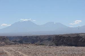
We had a applied for a permit for the volcano couple San Pedro / San Pablo and also received it. But these two are even a little more remote and the climb is more laborious than Acamarachi. Besides, the shortest access is on the south side which is longer in the shadow, therefore not very suited for long day trips.
We had withdrawn San Pedro and San Pablo from our program because after Acamarachi and Toco nobody had a big desire to four days camping at the mountains any more.
niemand mehr so recht Lust auf vier Tage Zelten am Berg hatte.
The image shows the two mountains seen from Lasana, distance about 50 km. |
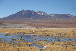 |
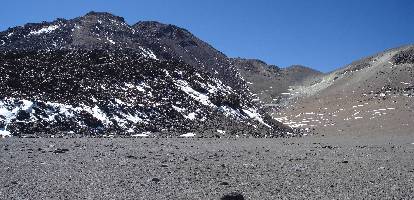
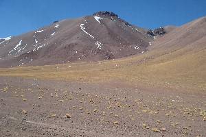
The Tatio volcanoes from a small chain east of the Tatio geysers. It is hard to find on the map which one is Tatio, Tatio Norte or Tatio Sur.
We believe that the southermost mountain of the chain is Tatio Sur, and this one was our aim.
It is characterized by steepening, delicate rubble slopes. From the pass at the road south of the Tatio geysers (4400 m), we traversed a small road into a valley and from there we went directly up; as it steepened we moved up leftwards.
At the right side it looked like a rock band would block the slope, maybe not passable.
On the top there is a vast plateau (about 500 m long); the highest of the three summits is the southernmost with 5200 m. The final 150 height meters to the north ridge were 45° steep, practically completely loose rock. Very delicate and awkward. For the descent I could find a scree couloirs a few meters to the east.
Ascent time 4-5 hours, the descent is considerably faster.
Our ascent is on the back side of the mountain and cannot be seen on the image. |
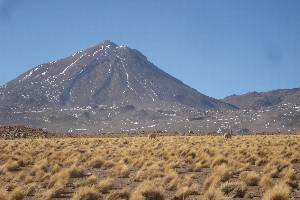 |
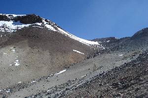
Claudia climbed Cerro Colorado from a height of 4550 m from north-northwest. The lower part is not too coarse rubble, which can be walked more or less well.
From about 5000-5100 m on, the terrain is steeper and merges to the north ridge; the ridge is peppered with very big, loose rocks.
The descent is better done further right, where one finds finer grained scree slopes. Ascent about 5 hours. Also here: Descent much faster, about 2 hours. |
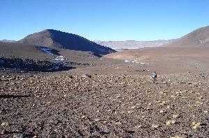
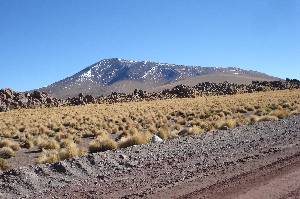 | This hill can be accessed up to 4550 m by car from the north. From there the mountain is an easy hike through puna grass; slowly steepening terrain leads up directly to the summit. The time for the ascent strongly depends on the state of acclimatization; since this mountain is preferably used as a first accliatization step, one can expect any time from 1 to 3 hours for the ascent. |
 |
We failed at Sairecabur, because there was too much snow on the road. We had to leave the car at 5120 m; if the road is free of snow, one can drive up to 5700 m.
In the upper region, the road leads through several small plateaus without much height gain, and traversing these plateaus on foot is a rather tough walk.
If one can (could) drive to the end of the road, probably it is only a stone's throw to the summit. At the very summit there is a little climbing on very big rocks - at least we remember such things from our climb in 1996 when this road did not yet exist and we had come from the north.
From the north there is a road which already in 1996 had been in quite bad condition. According to Openstreetmap it leads up to 5250 m, and on the satellite image it can be seen up to the area between Saciel and Sairecabur. If that is better than the newer road on the south/west side, I cannot tell. |
 |
Cerro Toco is the most visited 5000 m peak in the area, many agencies offer it as a half day trip.
From the road to Paso de Jama, at 4250 m an unpaved road branches off, leading to the base of Toco up to 5250 m. It is in much better condition than e.g. the road at Sairecabur. So the summit is only a 350 m height gain away, and this can be done on a well-worn trail - unique in this area where any other mountain climb involves more or less delicate balancing over some loose pebbles. The main summit can be easily identified by the broadest trail which leads to there. The - more snowy - western summit is about 10 m lower. There is an excellent panoramic view from the main summit, and this is also one of the few point from where one can see the ALMA telescopes really well. Take a camera with a good optical zoom. |
 | This is a small satellite of Pili which offers a good view for a reasonably small effort. From Pili base camp (4575 m) climb the south-west slope. First a bit to SE, crossing a gully; then, where the terrain allows turning towards NE, follow the slope upwards. One can see only the slope, making orientation a bit difficult. The summit comes into view only about 100 height meters before. No technical difficulties, walking terrain with sometimes a bit loose scree (but better than at Tatio or Colorado). 2-3 hours for the ascent, 1 hour for the descent. |
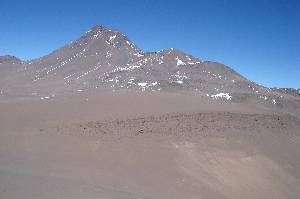 |
Acamarachi is the highest mountain of Cordón de Puntas Negras and the only 6000 m peak within a radius of about 100 kilometers. In its central position, it has several neighbours at almost the same height,
therefore it can hardly be seen from further away. Like most mountains here it is a volcano, but obviously it had not been active since a few thousand years.
It has a tiny crater lake of about 10 meters diameter which at our visit had been covered by a collapsed ice layer. Since the new road to Paso de Jama had been built, the easiest access is Salar de Pujsa in the north. With a car more or less suitable for dirt roads, one can follow the tracks from Ch-27 to the south. The small river north of Cerro Negro de Pujsa can be crossed at a suitable ford which should be carefully explored (mostly the river is frozen with running water below). The base camp (about 20 km from the paved road) is at 4575 m at the creek west of Cerro Negra de Pujsa where the valley bend from a north-south to a northeast.southwest direction. From here one can see very steep vehicle tracks further up to southeast which can be used only with a very good all terrain vehicle. I have found some advice that one should not drink the water in the creeks around Acamarachi because of arsenic pollution. From the casecamp, follow the vehicle traces to the saddle in the southeast and from there traverse into the valley southeastward, towards Acamarachi, with a height loss of about 35 meters. Where the traces end, there are some good places for camp 1 (4880 m). The sun disappeards quite early behind the mountain, but in the morning it comes very early. From camp 1, the route follows the valley between Acamarachi and the small hummock directly north of it, in order to reach the high plain called "shoulder". There is no continuous trail, even if time and again there is a kind of trace for a few meters. Painful ascent on loose rock the the "shoulder", 5470 m. Until here it took 3 hours for us. From the shoulder, we followed the left hand side ridge which is not very pronounced. Here we sometimes found pieces of beaten path, and in between these paths there are again loose rocks. The terrain is steep (35°), but one gains altitude quite fast. Sometimes it is useful to use the hands. This route does not agree with the description in During the descent it is worthwile to visit the small lake west of the summit, it is considered one of the highest lakes in the world. On the satellite image, unfortunately it can only hardly be seen. On the descent to the shoulder we followed a well trodden trace on the right side of our ridge, but this trace leads to the top of a steep precipice. We then traversed back to our original trace through delicate scree with vertical cliffs. Better don't even go down there! Back the camp 1 about 1-2 hours. The track on the map also shows our error in the descent. |
 | Cerro Corona probably has its name from the many small summits on its former crater edge; from far away the look like a little crown. The mountain is (rightly) not often visited. Starting point is the pass at 4350 m on the way from Talabre to Laguna Lejía. From there go eastwards towards the right end of a ridge coming down from the summit. Follow this ridge up in northeasterly direction; mostly the rocks/scree are more or less solid. At 5050 m the base of the actual "crown" is reached which consists of loose scree. Having fought your way to the summit "plateau", you have to have to find the right one out of all those small rock towers - that one which carries the summit box with the book. 4 hours from the pass, descent 1-2 hours. In the upper part very loose rubble, in the summit region very steep. |
| Date Night to.. | Type | Location | Height (m) | Cost |
|---|---|---|---|---|
| 05.08. | Hostal | Hostal Doña Sixta, Calama | 2250 | $72000 for 2 two-bed rooms |
| 06.08. | Hostal | Hostal Doña Sixta, Calama | 2250 | $72000 for 2 two-bed rooms |
| 07.08. | Hostal | Residencial Chiloe, San Pedro de Atacama | 2400 | $60000 for a 4-bed room |
| 08.08. | Hostal | Residencial Chiloe, San Pedro de Atacama | 2400 | $60000 for a 4-bed room |
| 09.08. | Tent | above Baños de Puritama | 3650 | - |
| 10.08. | Tent | west of Láscar | 3900 | - |
| 11.08. | Hostal | Residencial Chiloe, San Pedro de Atacama | 2400 | $60000 for a 4-bed room |
| 12.08. | Zelt | Geysers del Tatio | 4300 | - |
| 13.08. | Zelt | sulfur mine near Cerro Colorado | 4550 | - |
| 14.08. | Zelt | sulfur mine near Cerro Colorado | 4550 | - |
| 15.08. | Hostal | Residencial Chiloe, San Pedro de Atacama | 2400 | $50000 for a 4-bed room without private bath |
| 16.08. | Hostal | Residencial Chiloe, San Pedro de Atacama | 2400 | $50000 for a 4-bed room without private bath |
| 17.08. | Tent | camp 1 Acamarachi base camp Acamarachi | 4900 4580 | - |
| 18.08. | Tent | base camp Acamarachi | 4580 | - |
| 19. - 23.08. | Hostal | Residencial Chiloe, San Pedro de Atacama | 2400 | $60000 per night for a 4-bed room |
| 24. - 26.08. | Hostal | Hotel del Valle, Calama | 2250 | $30000 per night for each room, one 3- and one 2-bed room |
| 27.08. | Hostal | Hostal Americano, Santiago | 500 | $58000 in total for one 3- and one 2-bed room without private bath |
![]() This page is confirmed to comply with the HTML 4.0 standard.
This page is confirmed to comply with the HTML 4.0 standard.
Last updated November 04, 2016 by Hartmut Bielefeldt