| Home |
| Mountains |
| Expeditions |
| Minya Konka 2001 |
| Map |
| Height diagram |
| Info |
| Slideshow |
Home |
Back to "Mountains" |
Back to "Expeditions" |
Trip report Minya Konka 2001 |
Height diagram |
Info Minya Konka |
Deutsche Version |
Supported by |
Map sketch Minya Konka
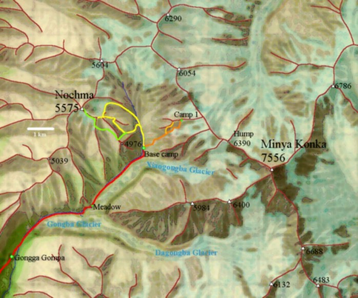
For copyright reasons, I can only give a general sketch of the area here. The sketch is based on the map "Map of Glaciers of Mount Gongga" 1:25000, Surveyed and compiled 1982-1983 by the Lanzhou Institute of Glaciology and Geocryology, Academia Sinica and the Multidisciplinary Research Team on the Qinghai-Tibet Plateau, Academia Sinica, Published by the Cartographic Publishing House, Printed by the Zhonghua Printing House, Shanghai, 1985.
Besides our campsites, the following routes are marked by colors:
- our way to the base camp in red
- the route to camp 1 in orange
- the unsuccessful attempt at the Pyramid in light orange
- the unsuccessful attempt at Nochma in yellow
- the successful climb of Nochma in green
Home |
Back to "Mountains" |
Back to "Expeditions" |
Trip report Minya Konka 2001 |
Height diagram |
Info Minya Konka |
Deutsche Version |
Supported by |
![]() This page is confirmed to comply with the HTML 4.0 standard.
This page is confirmed to comply with the HTML 4.0 standard.
Last updated July 29, 2001 by Hartmut Bielefeldt