| This document in the internet: www.bielefeldt.de/ladakh24e.htm |
Home |
Back to "Mountains" |
Back to Expeditions |
Map sketch |
Height diagram |
Info |
Deutsche Version |
Print version (no menus) |
| Quick overview - mountains | ||||
| date | mountain | height | gap height | |
| 02.08. | Ridge north of Upper Sapi Lake | 4785 | 85 | |
| 03.08. | southern pre-summit of Barqphoche | 4049 | 89 | |
| 08.08. | Nina´s Peak (Hemar Ri) | 5700 | 230 | |
| 12.08. | Chomo Chonkar Ri I | 6199 | 269 | Claudia, Hartmut |
| 14.08. | Chomo Chonkar Ri I | 6199 | 269 | Claudia, Nina |
| 15.08. | Pologongka | 6385 | 1265 | Claudia, Hartmut |
Ladakh 2024:
1. Trekking in the west:
Yogma La - Shinguche La (Chomotang Region)
2. Trekking in the east:
Pologongka Group
27. Juli - 18. August 2024
Claudia Bäumler, Hartmut Bielefeldt, Nina Bielefeldt
Author of this text: Hartmut Bielefeldt
Introduction
Six years have passed since our last greater vacation, including the very restrictive Corona times and the subsequent period of uncertainties about planning any kind of trip. But this year, finally time has come again for a big journey. For the fourth time, we are heading to Ladakh. Unfortunately, this time there will be only the three of us, since long trekking stages at high altitude would be out of scope for Henning and Marion.
As our destination we have chosen the Pologongka group (between Tsomoriri (see 2015) and Indus), because there was hardly any information available - except that there should be some technically rather easy 6000 m peaks, possibly some of them even unclimbed yet. The first climbs there were recorded in 1997, the second highest peak of the group (Guide Ri) was first climbed in 2018.
For this trip, our proven local agency Gesar Travel has put together a very different itinerary for us: we will travel overland from Srinagar to Ladakh and gradually work our way to higher altitudes through the relatively little-known western part of the territory until we undertake an initial five-day trek in the Zanskar Range (the summit objective at the end is still undecided at the planning stage). After a rest day in Leh, we will then spend six days in the Pologongka group. That part will be organized more "on sight," since even the campsite locations there have not yet been fully determined. Altogether, the whole journey definitely has a some expedition-like character.
Trip report
Friday July 26
Friedrichshafen - ZürichOur flight from Zürich will depart on Saturday at 10:50. During our planning we had overlooked that - on saturdays - the ferry to Romanshorn doesn't leave until 7:20. Therefore we're already leaving on Friday afternoon with an overnight stay near the airport. This has the additional advantage that we can watch the entire opening ceremony of the Olympic Games on TV, since tomorrow we only have to go 1 km to the airport.
Saturday July 27 / Sunday July 28
Flight Zürich - Istanbul - Delhi - Srinagar
After a short hike, we arrive at the terminal in ZRH early enough. (The tram costs CHF 4.60 for barely a kilometer - we're too fit and too stingy for that.)
We travel comfortably to Istanbul with Turkish Airlines, where we spend about five hours at a huge airport that was obviously built for much bigger tasks, with equally huge prices at the snack bars. At 8:30 p.m., we continue to Delhi on a flight operated by IndiGo, arriving after five and a half hours at 5 a.m. The immigration process is relatively quick, with hardly any queue at the counter. But it still takes a while until all fingerprints match and the passport photo and video recording have been verified.
The connecting flight to Srinagar departs from the same terminal, and we almost managed to stay inside the building. That is, until someone directed us to a door leading outside for the transfer flight. Instant climate shock - it feels as if you're being hit with hot, wet towels. But it's just the 29°C temperature and 100% humidity. For people wearing glasses, of course, the entire view fogs up immediately. We patiently queue once again at the entrance security check and, after fifteen minutes, are back in the air conditioning. About two hours later, the check-in counter finally opens. What follows is a short flight with a hectic breakfast on board, because shortly after reaching cruising altitude, the descent for landing already begins.
At Srinagar airport, we are picked up by a driver on behalf of our trekking agency and taken to the houseboat - or rather, to the little jetty opposite it, because included in the price of the houseboat is also the leisurely lake crossing by shikara. The houseboat is very luxurious: we have two bedrooms, a dining room, a lounge, and a lovely little "terrace" at the end of the boat. Dinner and breakfast are served on board.
 Srinagar: Shikara to the house boat |
 House boat at Nigeen Lage |
Monday July 29
SrinagarOur driver picks us up at the agreed time for the city tour. First we visit the Hari Parbat fort hill; after this, heavy monsoon rain makes excursions a little less pleasant. We visit the large Jamia Masjid mosque (with an architecture quite unusual for a mosque), the Shah-e-Hamadan Masjid, and the Nishat Bagh gardens on Dal Lake. Apart from a few more mosques and a floating vegetable market on the lake (for which one would have to get up very early), there is not that much to see in the city of Srinagar with its 1.2 million inhabitants. Since Srinagar is located in Jammu and Kashmir, for which many countries have issued travel warnings or at least travel advisories, there is hardly any international tourism. The main clientele consists of Indian tourists escaping the heat in their hometowns for a few days on a houseboat. At around 30°C during the day, we found it more bearable than Delhi, but as Central Europeans we would not really describe it as a pleasant summer climate.
 Hari Parbat |
 Jamia Masjid |
 Nishat Bagh, one of the Mughal Gardens around Srinagar |
 Nigeen Lake |
Tuesday July 30
Srinagar - Zoji La - Kargil - ShergolOur guide Norbu had already stopped by yesterday evening to discuss the plans for the first few days. We are picked up at eight in the morning and begin our journey to Ladakh along National Highway 1. From Srinagar (1700 m), we follow a green valley with forested slopes to Sonamarg (2600 m). What strikes us as unsettling is that along almost the entire route there is an armed soldier standing by the roadside roughly every 300 meters (at least). However, this may also be due to the large pilgrimage festival near Sonamarg.
But along those 80 kilometers there are other things one first has to get used to as well: Indian traffic itself. Consideration for others - something that still exists in Germany at least to some extent - seems to be completely unknown here. Every tiny gap is used to get a little farther ahead than everyone else. Honking, pulling into the oncoming lane, and then just seeing what happens. If someone is coming the other way, maybe they'll give way after all? And if not, you simply swerve back to the left at the very last second. The Border Roads Organisation (BRO) has put up many amusing signs that are actually supposed to warn against exactly this kind of nonsense. My favorite: "Drive like hell and soon you are there." Slightly more puzzling: "Please follow traffic rules" - do such things even exist here? So at least things are not boring for the time being, even though our driver is comparatively gentle behind the wheel.
The first and most important pass on this route is the Zoji La. Ladakh can only be reached via two roads: NH1 from Srinagar and NH3 from Manali. Both routes cross several very high mountain passes and are closed during winter. All freight traffic into the territory of Ladakh is handled during the short summer season by trucks traveling along these roughly 400 km routes; accidents are frequent due to driver fatigue, poor vehicle conditions, and weather-related factors. The Zoji La is currently being tunneled, and the road is expected to be completed in 2026, which would provide Ladakh with its first-ever year-round connection. It is an impressive construction project, comparable in scale to the Arlberg Tunnel (including access roads), and for India it is also a highly significant strategic infrastructure project.
 Zoji La pass road |
 |
 Zoji La |
After crossing the Zoji La (3,550 m), the landscape changes very rapidly: until then, we had been traveling through terrain reminiscent of the pre-Alpine regions, with forests and meadows similar to those in the Bregenzerwald, but it soon becomes barren and dry. We pass through Drass, the coldest inhabited place in India. Due to its unique location, winter temperatures there often fall below -25°C and have reached record lows of -45°C. Politically, Drass is also highly exposed, as the Line of Control is only a few kilometers away. The last war with Pakistan took place here in 1999. The district capital, Kargil, once probably held some importance as a hub for caravan routes between Kashmir, Ladakh, and Baltistan, but today it has little to offer apart from a market.
Shortly after Kargil, a traffic jam formed. We heard that some madman was throwing stones at cars. And indeed, a fairly aggressive man came running toward us with a stone in his hands. When he was about 50 meters away, our astonished driver executed a very quick U-turn. Together with everyone else stuck in the jam, we avoided the problem by taking a side road known to our local companions. Strange things happen...
We turn off at Shergol into a side valley and reach a homestay in the hamlet of Serjing (3250 m), where we settle into a cozy triple room.
Wendesday July 31
Urgyen Dzong (acclimatization hike), 400 HMFrom the parking area above the "village" (3420 m), we hike through a very narrow gorge on a well-maintained trail. The path is currently being repaired in several places because a major pilgrimage festival will take place in two weeks. At 3700 m, there is a small monastery perched on a ridge. Opposite, built into the rock face, lies the Urgyen Dzong cave monastery, where according to legend Padmasambhava meditated in the 8th century and thereby freed the region from evil spirits. After visiting the monastery and taking a lunch break, we begin our return hike. It is sunny and very warm, and at this altitude there is hardly any shade. Only a few trees grow here, limited to places where spring water emerges from the ground.
 Way through the gorge to the hermitage |
 |
 Ugyen Dzong |
Thursday August 01
Drive Shergol - Mulbekh - SapiFrom the homestay, we return to the main valley, visiting the hermitage monastery of Shergol, the large Buddha statue at the entrance to Mulbekh, and the monastery above the village. By now, we are starting to feel a bit "over-monastered," so we are not too disappointed that the monk with the key to the last monastery cannot be found.
We drive back via Shergol up to the Sapi La (4400 m). The road is narrow but in very good condition; it is probably no more than two or three years old. Apparently, there is still plenty of work for the Border Roads Organisation to push into even the most remote corners of the country. But it is also understandable - Who would want to live today in a hamlet that requires two to three days of walking to reach? On the other side, we descend to Sapi, but the exact location of the homestay is not entirely clear. At the end of an adventurous road, we have to wait a bit until Norbu guides us to the right house. Our luggage has already arrived, carried up on foot by the helpers. This homestay is a farmhouse at 3980 m, surrounded by barley fields. Life here is simple: the toilet is an outhouse pit latrine, with the path running around the outside of the house. Washing water comes from the stream next to the house. Dinner and breakfast are good and sufficient, and we gradually get used to Ladakhi cuisine. The farmers keep several yaks; a yak cow and her calf are in the barn next to the house, and the baby yak looks very cute. After this night, we also understand why they are called "grunting oxen".
 The large Buddha of Mulbekh |
 Homestay at 4000 m |
 a comfortable room |
 Yak and little yak |
Friday August 02
Acclimatization hike to the upper Sapi Lake, 800 HMShortly after setting out, we encounter our first technical problem: Nina's MP3 player runs out of battery. Still, we do not turn back; instead, Nina passes the time talking with us and Norbu (in English, of course). We hike up endless grassy slopes. Above 4000 m, many flowers are in bloom - these are the grazing areas. It takes three hours until we finally reach the glacial lake at 4700 m. Norbu produces a melon from his backpack that is far larger than our appetite. (The rest is, of course, carefully packed and carried back down.) In a spectacular high-mountain setting, we climb the small hill beside the lake, reaching 4785 m, and then descend again to the homestay.
 walking towards Sapi Lake |
 Sapi Lake, 4700 m |
 |
 Edelweiss |
We continue our drive over the Namika La to the next homestay in Yogmal (3630 m). Here we again have a bathroom with a sit-down toilet, and apart from brief interruptions, there is also electricity. In the evening, there is a longer rain shower.
 The car is coming from the parking, we join here |
 Driving towards Namika La |
Saturday August 03
Yogmal (Bodhkarbu) monastery festivalBarqphoche sub-peak, 500 HM
At short notice, our guide learns that the annual monastery festival is taking place at the nearby nunnery of Bodhkarbu. The roughly three-hour masked dance is a fascinating spectacle, although we do not really grasp the details of what is being depicted.
 Nunnery Bodhkarbu |
 Mask dance at the yearly festival |
 |
At midday we return to the homestay; a short but intense thunderstorm makes the streams rise very quickly. In the barren landscape, the water runs off rapidly over the surface and collects in the valley, where it sometimes also causes damage to paths or bridges. In the afternoon, we hike up to a small sub-peak (4049 m) of a mountain marked as Barqphoche on the map. Since the route follows the ridge, we are far enough away from any possible flooding.
Sunday August 04
Drive to Kanji
We continue driving towards Leh, but at the junction to the third pass, the Fotu La, we stay in the valley and eventually reach the small village of Kanji (3840 m) at the end of a very narrow gorge and a rough, bumpy road.
Here the rest of the team joins us: cook Namgyal and assistant Tashi. Our tents are set up, and the kitchen is installed in a small room of a building that has clearly seen better days. But the roof is intact, which is most important in the afternoon rain. One of the rooms also serves as a "store", where we can wait out the heaviest part of the downpour.
 The team is coming: Helper Tashi and cook Namgyal |
") Campsite in Kanji (3840 m) |
 Dinner "inside", outside it is raining |
Monday August 05
Trekking day 1: Kanji (3840 m) - Yogma La (4730 m) - Shillakong (4500 m)14 km / 1100 HM
The trekking routine begins at seven in the morning with morning tea; afterwards we pack our gear and sit down for breakfast at 7:30. The horseman arrives with horses and donkeys; while we are having breakfast, our tents are taken down. We set off with Norbu at 8 a.m.; meanwhile, the rest of the camp is packed up, and during the day the caravan will overtake us and set up the next campsite.
We hike through a very flat valley, initially somewhat monotonous along a dirt road. Soon, however, there is some variety: we have to cross a knee-deep stream. After the alpine pasture of Dumbur, where sheep and goats are grazing, the route continues towards the pass with magnificent views of spectacular rock mountains in a variety of (mostly impressively steep) shapes and colors. Shortly before reaching it, we are caught in a brief rain shower; right at the pass (4730 m), our baggage transport also arrives.
On the map, the descent had looked quite short, but in reality we traverse long stretches across steep slopes above deeply cut gorges. Rain sets in again, making the stream crossing just before the campsite quite adventurous. We also cannot wait for the water level to drop, as the rain will likely keep it rising for the rest of the day. So we have to get across while it is still possible at all. We arrive at the campsite together with the pack animals. Fortunately there is already a shepherd's tent, allowing us to take shelter for a while. Gradually the rain eases, and soon the camp is pitched. By dinner time, we can sit outside again.
 view back after the river crossing |
 the alp Dumbur |
 The valley widens |
 Just before the pass |
 The river is already quite high |
 At dinner time it is nice again |
Tuesday August 06
Trekking day 2: Shillakong (4500 m) - Shinguche La (5146 m) - Spangthang Tokpo (4710 m)10 km / 800 HM
The morning routine is the same as yesterday. The trail crosses several side streams, which can still be negotiated with normal hiking shoes. Afterwards, the ascent continues at a moderate gradient through grassy terrain, passing many outlying rock spires, before climbing steep scree slopes up to the Shinguche La (5146 m). On the other side, the descent initially leads over monotonous scree slopes, then follows a stream flanked by impressive rock formations. The campsite is set at 4710 m, just before a stream crossing that will likely be easier in the morning.
In the afternoon, Claudia scouts a possible route up towards Nigutse South, reaching up to 5100 m. The mountain looks quite interesting, but higher up in the scree-covered terrain no suitable campsite can be found. From here, it would be more than 1000 meters of ascent in a single day, which is too much given our still rather limited acclimatization.
 The pass is hiding behind the rock pinnacles |
 |
 |
 a rare halo with two rings |
 Shinguche La, 5146 m |
 From above, the path ahead appears somewhat desolate... |
 ...but soon becomes quite scenic |
|
 |
 |
 in the back Machu Kangri, a nice 6000 m peak two valleys away |
Wednesday August 07
Trekking day 3: Spangthang Tokpo (4710 m) - Spang Nala (4840 m)7 km / 400 HM
Amid constant bleating - for most of the way we are accompanied by a herd of about 300 sheep - we set off southwards, where the base for our mountain ascent is to be established at the Spang Nala. The trail traverses about five kilometers with gentle ups and downs before we encounter the challenge of the day: the crossing of the Spang Nala river, which is roughly waist-deep and quite fast-flowing, with typical glacial-stream temperatures. On the other side, our campsite is soon reached. Shortly afterwards, the other three helpers arrive with the horses and set up the tents. The afternoon is rather cold and windy, but the location offers beautiful views of glaciated mountains in the background and of our objective for tomorrow, which rises directly behind the camp.
 Breakfast |
 Soon they´ll go back to work |
 Strange rock towers interrupt the plateau |
 this mountain tomorrow") We will visit (and name) this mountain tomorrow |
 The toughest river crossing of this journey |
 Camp at 4840 m |
Thursday August 08
Trekking day 4: Hemar Ri (Nina´s Peak), 5700 m7 km / 900 HM
We set off at five in the morning, when it is just about getting light. Through more or less steep scree slopes, we search for the best approach to the north-west ridge of our mountain. The ridge itself turns out to be an easy scree back. Unfortunately, the clouds are drawing in more and more, so we can hardly see the views and cannot make out where the actual summit is. At 5620 m, the north-west ridge joins from the left, and from there the ridge gradually continues to rise towards the south. After two small subsidiary summits, we reach what appears to be the highest point; the GPS shows 5699 to 5700 m. There are no signs of previous ascents: no prayer flags, no cairn, and nothing that looks like a collapsed cairn either. So we are probably the first to reach this summit. A strange feeling.
We build a small cairn - there is plenty of material - and place a note with our names inside it, sealed in a plastic bag. Unfortunately, we do not have any prayer flags with us; we had planned to buy them in Leh. We manage to enjoy a bit of the view in various directions, as far as the clouds allow, before descending again by the same route. The descent to the camp takes an hour and a half; the ascent had taken four hours.
 |
 |
 Search for the best access |
 The summit ridge seems endless. |
 |
 This will probably be the summit |
 View to the south. Many mountains, few names. |
 Southwest, mountains at the head of the Spang Nala valley |
 The first cairn on this mountain |
 |
 Descent |
 Spang Nala Valley. There would be still quite a lot to be done.") Head or (our) Spang Nala Valley. There would be still quite a lot to be done. |
The rest of the day is, as one might say, "at leisure." We rest, sleep, eat, and play Monopoly or Uno.
Friday August 09
Trekking day 5: Descent to the road at Sirsir La; Drive to Leh5 km
A relaxed hiking stage: an hour and a half descending through the valley to the road at Sirsir La. No river crossings or other adventures; along the way we meet a shepherd, around 300 sheep and various goats, and nobody else. During the last few days as well, apart from us and a few local herders, there was nobody on the trail.
The horseman receives the remaining food supplies and sets off with his animals back to Kanji, following the same route as our trek. Soon a minibus arrives, and all of us, together with the equipment, are taken to Leh. At first, the road to Hanupatta is little more than a dirt track, but construction is going on everywhere. Presumably, there are more migrant workers from Bihar in the entire valley than local residents. The valley narrows into a very tight gorge; after 30 kilometers we reach the NH1 - finally a two-lane road again. From there, the route follows the Indus upstream for most of the way. There are occasional irrigated patches alongside the river, but in between lie stretches that are almost canyon-like. There is really not much usable space for settlements here.
After about five hours on the road, we arrive in Leh at the Yartsa Guesthouse, where our host Diskit welcomes us warmly. In town, we find that the former Penguin Restaurant now bears a different name, "Lamayuru," but at least they still serve something resembling Western food - even if it does not quite match the Penguin's Chicken Cordon Bleu.
 Brilliant morning: Chomotang is just over 6000 meters high. |
 We walk downstream towards the road. |
 The first sections of the road are quite rough |
Saturday August 10
Rest day in Leh
A rest day - and no sightseeing program either, since we had already seen much of Leh on previous visits. One particular luxury is that we can have our laundry done at the guesthouse; many thanks to Diskit for that.
We spend the day strolling through the market, where a handicrafts exhibition is taking place, and browsing one or two shops.
Two side notes: Leh now has a supermarket where many ordinary groceries are sold at the MRP (maximum retail price - printed on the products and usually quite reasonable). They also stock many imported items such as cheese and chocolate, some of them at rather outrageous prices (not displayed and only available on request). In addition, there is now a Decathlon store on the outskirts of town, although its range of products still leaves plenty of room for improvement (a few jackets hanging in the showroom).
At the beer shop, we run into the shopkeeper from Kanji again; here he buys the beer that he later sells in his store in Kanji - at a very fair price considering the effort involved.
Dinner with Norbu at the "Lamayuru."
 Yartsa Guesthouse, Leh |
 The beautiful garden of the guesthouse |
 Picture with Diskit, the guesthouse owner |
 Bazar / pedestrian zone, Leh |
Sunday August 11
Drive via Taglang La to Pologongka La (4980 m)Trekking day 1: Ascent to camp 1 at Pologongka (5280 m)
2 km / 300 HM
Our guide Abhishek, who will accompany us on the next trek, picks us up at 8 in the morning. Namgyal and Tashi are with us again. We drive via Karu and Upshi along the Manali-Leh Highway, crossing the 5330-meter Taglang La on the way to Tsokar - a route we already know from our 2015 trip to Ladakh. This time, however, we continue along the northern edge of the salt lake toward the Pologongka La. The road is narrow, but it seems to have been paved only recently; in some sections, construction work is still underway.
At the pass (4,980 m), Abhishek sets off with us in cloudy weather to look for a campsite. The rest of the team waits by the roadside for the pack animals. After an hour and a half, we find suitable ground at 5280 meters. It starts to rain, but there is still no sign of the horses for a long time. The four of us wait for an hour under a single umbrella until the rest of the team finally appears. After that, however, camp is set up quickly and efficiently.
In contrast to the first trek, we are not following an established trekking route here, but rather aiming to explore the little-known Pologongka mountain range. Accordingly, no one is familiar with this area, and there are no established campsites with leveled ground suitable for pitching tents. The best compromise is a stone-free area with a slope of about 5 to 10 degrees for our tent. The night is not really comfortable, as we keep sliding down the sleeping mats toward the tent entrance.
 Nine years ago it said "second highest", meanwhile someone must have checked the measurements |
 We march ahead before the pack animals arrive. |
 One umbrella for four, waiting for the team |
 Soon the kitchen tent is pitched, the stove is working |
 |
Monday August 12
Trekking day 2: Chomo Chonkar La, Chomo Chonkar Ri I (6199 m) and back10 km / 950 HM
During the night, there was some fresh snowfall at higher elevations: the mountains are lightly dusted, and the weather looks mixed. We explore the further course of the valley. Occasionally, faint trail traces and cairns can be seen, but overall the high valley is a rather barren landscape of scree, interrupted only by very sparse vegetation. At the end of a flat, gravelly plain we reach the pass (5815 m), from where we can catch a glimpse of Chomo Chonkar Lake on the other side. At 5650 m, it is one of the highest lakes in Ladakh, about one kilometer in length.
We avoid the ascent on the way back and do not descend into the closed basin toward the lake. Since the weather, despite the cloud cover, looks reasonably stable and the 550 meters of elevation gain up to this point went quite quickly, we turn north toward the nearest peak. (The mountain to the south, with its steep scree slopes, looks rather inaccessible.) After two hours through a strenuous but technically easy scree slope, we reach the summit of Chomo Chonkar Ri I; the GPS reads 6200 meters. Despite some clouds, the panoramic views are quite good, and from here we can finally also take a look at our main objective, the Pologongka.
For the descent, we choose the north ridge, crossing a small, almost crevasse-free glacier to the pass below the Pologongka, then passing a frozen lake before making our way back through long scree plains and valleys to our campsite.
Nina did not sleep well and takes a rest day at camp.
 Further up, there was some snow. |
 Chomo Chonkar Lake, 5650 m |
 We go up further through the scree |
 Chomo Chonkar Ri I, 6200 m |
 |
 Descent to the other side |
Tuesday August 13
Trekking day 3: camp 1 - camp 2 - Chomo Chonkar La - camp 25 km, 550 HM
There was frost during the night, but inside the tent it is still quite comfortable at 8°C.
Since the camp is too low for the main summit of Pologongka, we move camp to a site 300 meters higher. From yesterday's observation, there should be a viable camping spot at 5650 m. Abhishek had originally intended to go even higher, but the horses cannot make their way through the boulder terrain into the upper valley. Moreover, his planned overnight altitude of 5900 m would likely not be very comfortable for anyone and, in terms of the summit objectives, would also be unnecessary.
Claudia and Nina continue as far as the Chomo Chonkar La to get a view of the lake. In the afternoon - fortunately after camp has been set up - there are a few hail showers, but also repeated spells of sunshine in between. In the evening, we discover a small mouse in the vestibule of the tent, which looks quite hungry.
 In the afternoon again there is a snow shower |
 Later it is nice again. |
 Monopoly at 5650 m |
 A small hungry visitor |
Wednesday August 14
Trekking day 4:Hartmut: attempt at Chomo Chonkar Kangri (up to 5935 m), 3 km / 300 HM
Nina, Claudia: Chomo Chonkar Ri I (6199 m), 7 km / 600 HM
Summit day for the main peak of the group, the Pologongka. After Nina had a very poor night's sleep, we spontaneously change plans: Abhishek and I attempt Chomo Chonkar Kangri instead, setting off at 6 a.m.
The weather does not look very promising - it is overcast and a strong wind is blowing. The north face of the mountain mainly consists of loose scree, making progress extremely difficult. The snowfields are only a thin layer of snow hiding hard, exposed ice, which at a steep angle (>45°) is far from ideal.
As a result, we turn back at 5935 m, and unfortunately we will not find out whether this mountain is still unclimbed. If it is, it will likely remain so for the time being.
With a better route choice further to the left, we might have gained a bit more height, but it would probably have become equally steep and loose higher up.
We are back in camp by 8 a.m.
Claudia and Nina set off at nine o'clock with Abhishek toward Chomo Chonkar Ri I. Concerning choice of best route, there are apparently some differences in judgment between Indian guide and German Alpine Club instructor. The latter prevail, and after 3 1/2 hours they reach the summit - Nina's first six-thousander.
Fortunately, they are back in camp by 2 p.m.: after it had been sunnier around midday, hail and rain set in repeatedly throughout the afternoon.
 |
 Beyond the moraine slope, we reach the ice lake |
") Ice lake (5930 m) |
 Last meters at Chomo Chonkar Ri I |
 Nina´s first 6000 m peak |
 Descent towards the lake resp. Chomo Chonkar La |
Thursday August 15
Trekking day 5: Pologongka (6385 m)8 km / 800 HM
Nina's enthusiasm for another six-thousander is rather limited, so Claudia and I set off with Abhishek toward Pologongka without her. After passing the frozen lake, we soon reach the glacier and cross a crevasse-free glacial basin toward the east ridge of the Pologongka. The 250 meters of ascent along the ridge seem endless, and the altitude is clearly noticeable. The route is not technically difficult, and we can go without a rope: the few small crevasses are easy to see. Toward the end, the ridge gradually flattens and turns into a summit plateau. The highest point is marked by prayer flags at 6385 m - our highest peak since Ojos del Salado, and that was already 18 years ago.
Once again, a few clouds have moved in, making the panorama less clear. To the south, we can make out Tso Moriri, Spangnak Ri, and the Mentok and Gyama ranges, where we were traveling in 2015; to the left of Tso Moriri lies the Chamser-Lungser group, which has not been accessible to tourists for the past ten years. Beyond the Indus, only the pyramid-shaped peak of Chakula is visible. We hang up our prayer flags and set off on the return after half an hour. The descent back to camp takes less than two hours.
 Ascent to Pologongka |
 Chomo Chonkar Ri I |
 Beginning of the northeast ridge |
 a frew small crevasses |
 The summit is a large plateau. |
") Pologongka (6385 m) |
") View to Tsomoriri and Gyama Peaks (visited in 2015) |
Back at camp, we are welcomed with juice and are also meant to receive the lunch we missed; it seems difficult to convey that on a strenuous day at altitude one simply does not have much appetite. Even resting in the tent does not help: after a short while I receive a "delivery" to the tent consisting of noodle soup, noodles with salad, black tea, and melon.
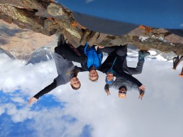
 Nina, Abhishek, Tashi, Namgyal, Claudia, Hartmut |
 We also get a cake with our peak heights |
Friday August 16
Trekking day 6: descent to the road at Pologongka La, 4 kmTravel back to Leh
Breakfast is at 7:30, and we are ready to set off by 8 a.m. Since camp first has to be dismantled, we only get going at 9. After an hour we reach the pass at the road and wait for a while until the loads arrive and the horses are unloaded. After that, the waiting continues, as there is no vehicle available. Since there is no mobile reception at the pass, Namgyal is given a ride in a passing vehicle so he can clarify the situation in the next village.
The car doesn't arrive until 12 noon, unexpectedly from the east. There had apparently been problems at the Taglang La, forcing the driver to take a 200-kilometer detour. The drive to Leh - 170 km - takes four hours, ending in heavy traffic. In the end, we are once again glad not to be driving ourselves.
 Soon the pass is in sight |
 Our valley, Pologongka itself is not visible |
 Waiting for the bus |
Saturday August 17
Rest day in LehRest day, souvenir shopping. Dinner at the restaurant Bon Appetit (northwest of Upper Tukcha Road), which we had not managed to find until now: they serve almost Western-style cuisine, and even beer.
 Leh |
 Breakfast in the guesthouse |
Sunday August 18 / Monday August 19
Flight Leh - Delhi, Delhi - Tashkent - Frankfurt
Fortunately, yesterday evening, while checking emails, I found that our flight from Leh to Delhi had been moved forward from 2 p.m. to 10:20 a.m. - otherwise we would have encountered an unpleasant surprise at the airport. Most likely there was not enough demand for two separate flights, so they were combined.
After an hour's flight, we arrive in Delhi and, in the usual chaos there, manage to find a reasonably official taxi with a fixed fare, which takes us to our pre-booked hotel. The international flight departs at midnight, so we are not actually staying overnight in Delhi. However, a hotel room was cheaper than storing our luggage for 12 hours. The hotel is, of course, only mid-range, but we are able to spend the afternoon there quite comfortably.
Any ambitions for sightseeing evaporate after a short trip to the nearest grocery kiosk: the weather is still exactly as it was three weeks ago, and we voluntarily do not leave the room even though it is only fairly air-conditioned.
 Flight over the Himalaya to Delhi |
 Delhi |
Three hours before departure, we are back at the airport. We quickly find the check-in counter - it is the one with the longest queue in the entire airport. Everyone seems to be carrying an enormous amount of excess baggage, which is then unpacked, repacked, reweighed, and repacked again until they disappear to the excess baggage counter to pay. These people are clearly carrying well over 20 kg.
In our case, however, the problem is a different one: after an hour it is our turn, and we are confronted with the question of how we intend to pay for our excess baggage - as our luggage is supposedly only booked through to Tashkent. With the help of a printout of our flight booking, we are able to prove the opposite, but convincing the Indian booking system of this requires several senior and very senior airport officials.
Passport control takes another 45 minutes. This is followed by security screening, which takes a good half hour. As expected, the number of batteries is again questioned and carefully recorded in a notebook, including what purpose we supposedly needed how many batteries for.
Thus we reach the gate just shortly before boarding, absolutely sta ving - we had actually planned to find a restaurant in the duty-free area for dinner. Instead, we quickly grab a few pastries from the bakery stand at the gate to avoid immediate starvation.
After the boarding process, during which the impatient elderly Uzbek ladies with oversized hand luggage are sorted out by the staff, we finally take our seats on the Uzbekistan Airways flight to Tashkent. From here on, things improve: the safety video is highly worth watching (see the ![]() Youtube video), and on the two-and-a-half-hour flight we are served a full meal.
Youtube video), and on the two-and-a-half-hour flight we are served a full meal.
In Tashkent, we spend three hours in transit, followed by a seven-hour flight to Frankfurt with dinner and breakfast served on board. From Frankfurt, we travel home by train without any problems.
Of course, this day is once again quite a long one: counting from Leh, we are traveling for 34 hours
At times it was strenuous, at times clearly beyond our comfort zone, and after three weeks we are also quite happy to be back in familiar surroundings at home. Still, looking back, it was a great trip with excellent challenges and rewarding experiences.
Technical hints about the images
After clicking onto an image, a larger version (height 768 pixels) will be opened in a new tab in the browser.
In this window, a manual or automatic slide show can be started:
- click onto the image -> next image
- click onto right arrow -> next image
- click onto left arrow -> previous image
- click onto clock -> next image, and automatically every 5 seconds the next image will be loadad. This can be interrputed again by one of the above mentioned clicks. The automatic slide show needs JavaScript.
If you don't like the image height 768 (e.g. on notebook or netbook computers): Normally you can change the scaling of the contents using Ctrl-"+" oder Ctrl-"-".
Home |
Back to "Mountains" |
Back to Expeditions |
Map sketch |
Height diagram |
Info |
Deutsche Version |
Print version (no menus) |
Hartmut Bielefeldt
Galleyenstrasse 19/2
D-88048 Friedrichshafen
© 2024 Hartmut Bielefeldt
![]() This page is confirmed to comply with the HTML 4.0 standard.
This page is confirmed to comply with the HTML 4.0 standard.
Last updated May 31, 2026 by Hartmut Bielefeldt