Home |
Back to "Mountains" |
Back to "Expeditions" |
Map sketch |
Height diagramm |
Practical information |
Deutsche Version |
print version (no menus) |
Chile 2016 - Mountains in Atacama
| overview - mountains | |||
|---|---|---|---|
| 08.08. | Cerro Jorquencal | 4971 m | all five went to the top |
| 09.08. | Cerro Corona | 5291 m | only up to 4760 m |
| 10.08. | Cerro Corona | 5291 m | Claudia |
| 12.08. | Tatio Sur | 5200 m | Hartmut |
| 13.08. | Cerro Colorado | 5748 m | Claudia |
| 14.08. | Sairecabur | 5971 m | only up to 5535 m |
| 17.08. | Volcán Acamarachi (Pili) | 6046 m | Claudia, Hartmut |
| 18.08. | Cerro Negro de Pujsa | 5135 m | Marion, Henning, Hartmut |
| 20.08. | Cerro Toco | 5604 m | Claudia, Hartmut, Marion |
| 22.08. | Cerro Toco | 5604 m | all five on the top |
Introduction
After two - avowedly very nice - trips to Ladakh, we wanted to visit an other region this year. Northern Chile became our choice: There are high mountains which can be visited during our summer school holidays. We organize this trip on our own. It will not be a trekking lasting for weeks; instead we want to tackle each mountain as a one or two day trip, and in between return to "civilization".
Trip report
Wednesday, 03. August / Thursday, 04. August
Flight Frankfurt - Madrid - Santiago - CalamaOur train journey to Frankfurt Airport goes smoothly until near the Airport. Then, for some time there is no movement at all, until the conductor announces a turn-around because of signal disturbances. Via Frankfurt Main Station, we arrvive at the airport with a delay of 1 1/4 hours. Until we finally find Terminal 2 our time buffer is mostly consumed (and our stress tolerance, too). But we reach the flight to Madrid in time. In contrast to Frankfurt, there the transfer to the other terminal is clearly signposted, the shuttle train station is announced doubtlessly. At 00:30 our flight to Santiago starts, around half past two we find some rest.
We reach Santiago well in time at 7:50 in the morning. A helpful gentleman leads us the way to the right counter and checks in our baggage (for a small tip). So we have enough time for a snack before the domestic flight. Two hours flight to Calama with a nice view to the mountain chain of the Andes, virtually void of almost all trace of human beings. Around Santiago, everything was heavily snow-covered, towards north the landscape becomes more grey.
At half past three in the afternoon we are at the hostel, after 34 hours of travel. But, there is nobody. After 1 1/2 hours an Nachmittags um halb vier am Hostal, nach 34 Reisestunden. Nur, es ist niemand da. Nach anderthalb Stunden macht ein älterer, an elder, hearing-impaired man opens the door, eventually we have a bed. This evening, we don't want to search for a restaurant and spend a long time there. Rather we go for a short shopping in the supermarket, have a cold supper in the hostel and are in bed at 7 o'clock.
 Santiago |
 Arrival in Calama |
Friday, 05. August
CalamaWe fell asleep quickly, but despite the tiredness due to the long journey, we can't sleep until sunrise at seven. This morning we fetch the rental car at the airport and go to the shopping mall. Due to several detours (road construction), this is rather cumbersome in an unknown town. Changing money in the bank is a time-consuming business, it takes half an hour. In the big supermarket, we do the big shopping for the mountain tours. A few things which would have been nice cannot be found like ravioli or other canned dishes. But most things are found. Dinner today in a Pervuian restaurant, it was the closest from the hostel. We already keep up until eight in the evening.
Saturday, 06. August
Calama - San Pedro de AtacamaThe nights are long if you go to bed so early. Around two or three o'clock everybody wakes up once, being used to that at home it would be eight in the morning. But more or less, we can sleep on until seven.
After breakfast in the hostal, we load our baggage into our car which hadn't appeared too small. But it takes some optimization, at the third attempt finally everything fits.
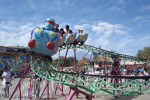
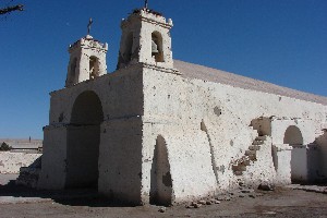
After some time we find the way out of Calama, and an hour on an excellent road brings us to San Pedro de Atacama. First we refill the tank, who knows when we'll get some fuel again. We soon find an affordable room 1; our walkabout through the village yields an arrangement of bouncing castles on the plaza. There's a lot of attractions on the "day of the child", for Nina a very lucky coincidence. At the parking lot there is a fairground with several different rides which are all free of charge. In the evening we have a good pizza in a restaurant.
 Church of San Pedro de Atacama |
 In San Pedro today is Children´s Day |
 |
Sunday, 07. August
Visit at ALMA
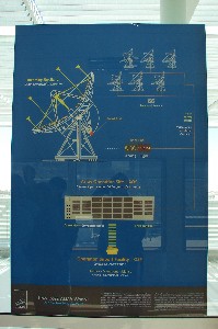
Reserved months ago, today our visit of the radio telescope ALMA (Atacama Large Millimeter/Micrometer Array) takes place. Since end of the 90s, one had found that the area around San Pedro offers unique environmental conditions for radio astronomy: very dry, hight altitude observation points minimize the absorption by atmospheric water vapour. The project ALMA is currently the world's most modern and powerful radio telescope. 66 single telescopes on the Chajnantor high plain, each with 12 m diameter, can be interconnected to different configurations which
- simply speaking - in the best case correspond to a single radio telescope of up to 16 kilometers diameter. The interconnection of these 66 telescopes is of course absolute high-tech, so not only the signal propagation time due to the different antenna positions must be compensated. It even is an issue that when they follow a certain object, the dishes will see different delays due to their inclination. All these calculations are done in a supercomputer which is situated close to the telescopes at more than 5000 m altitude, being waited by specialists with oxygen masks.
The evaluation of the data and the control of the telescopes is done in the command center at 2900 m, and that is what we can visit.
An English language tour explains us construction, operation and function of the site. The tour does not lead to the single telescopes, because they are at more than 5000 m altitude which is clearly too high for unacclimatized visitors. Besides, actually there is about 70 km/h wind up there, which would not be very comfortable. Altogether, however, the visit was clearly worthwile. And, it is for free, but the engagement of our guide was clearly more than what we could expect for our 1 Euro contribution which was paid by each taxpayer of EU/USA/elsewhere for this 1 000 000 000 US$ project.
 Our visit at ALMA with a competent guide |
 |
 The telescope area can be seen only on the screen |
 Transport vehicle for the telescopes |
In the afternoon we go to Valle de la Luna for the sunset. Since 20 years ago, a lot has changed here. The access costs an entry fee, and hiking is only allowed along a few marked paths. Considering the present visitor numbers, the sand dunes would surely be washed out. In 1994, we had been practically alone in Valle de la Luna.
 Valle de la Luna |
 A short walk in Valle de la Luna |
 Evening |
 Near the Great Dune |
||
Monday, 08. August
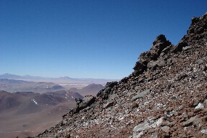
Cerro Jorquencal (4971 m)
First acclimatization mountain. On the way towards Tatio, we see Vizcachas and Guanacos. At 4550 m, we park the car in the puna and hike up Cerro Jorquencal (4971 m).
From here, it is only a grass and scree hill, but the altitude makes it tough. After all, we are not at all acclimatized yet.
After 2 to 3 hours, everybody reaches the summit, also Nina for whom not power or endurance was the major problem but rather the motivation.
Again, she copes best of all of us with the high altitude.
From Jorquencal, we go back towards San Pedro de Atacama in order to find a campsite at an acceptable altitude. Tatio at 4200 m would be too hight for the first night. A bit above the Baños de Puritama we find a good spot at 3650 m. The evening is short: Already before the sun sets, it becomes cold and we disappear in our tents.
 Our first mountain destination, Cerro Jorqencal |
") Guanaco (or vicuña?) |
|
 Starting the hike at 4550 m |
 Summit of Cerro Jorquencal, 4971 m |
 |
Tuesday, 09. August
Attempt at Cerro CoronaBy car, we go down again and continue to the southern side of San Pedro. Beyond Talabre at the road to Laguna Lejía, we find a flat area to pitch the tents at 3900 m. Henning and I go on to attempt Cerro Corona (5291 m). Already at the pass at 4350 m it is very windy. After 400 height meters, the wind besomes a nuisance, it has steadily increased and now blows with about 60 km/h. It is hindering the strenuous hike, and further up it probably will be more uncomfortable. We turn back.
At the campsite, Claudia, Marion, and Nina have pitched the tents, needing to level many treacherous small holes. Whereever we put our foot here in the sand, it will sink into a hole. 20 years ago we had experienced the same thing at our camp at Láscar - did we end up on exactly the same campsite?
Since we have a lot of time until dusk, we undertake an excursion to Laguna Lejía by car. From there on the backside of Láscar, the extinct volcanoes Aguas Calientes and Acamarachi can nicely be seen. We are planning to climb the latter, but from the other side.
 Laguna Lejía with the volcanoes Láscar, Aguas Calientes, and Acamarachi |
|
 Campsite at Láscar |
 Cerro Corona at evening |
Wednesday, 10. August
Cerro Corona (5291 m)In the morning, we have -10°C in the shadow around the tent. Unfortunately it is the shadow of Láscar which hides the warming sun for some time. Nina and I stay at the camp, we explore the surroundings and meet some Llamas which thoroughly sniff at us. The only one of the other three to reach the summit of Cerro Corona is Claudia. Though the wind was better than yesterday, the scree in the higher sections was very unpleasant.
In the afternoon we dismount our camp and drive back to San Pedro. There is a room in the same hostal as last time; besides a shower we can enjoy a meal without having to use the camping stove.
 Llamas |
 A rather nosey one |
") On the summit of Cerro Corona (5291 m) |
Thursday, 11. August
Drive to TatioOur permit schedules Cerro Toco (5604 m) for tomorrow, and afterwards Acamarachi (6046 m). We don't judge ourselves really fit for that altitude; we visit the carabineros in oder to change date and sequence of the mountains. After an initial "impossible", 45 minutes later a changed and reduced list is noted in the book of the station, and our absence at those mountains is thus registered.
Food purchase, bakery, a decent lunch - and we set out for Tatio. Near the village Tatio we encounter a beautiful lake where guanacos,ducks and many other animals enjoy the day. As we drive on, more and more dust enters the car interior. As we get off the car near the Geysers, we see the reason: The rear window is not there. After a few kilometers searching for the window, we suddenly understand what happened: The window was downed due to a wrong switching signal. I would not know how I could do that intentionally; but we soon find the switch to move it up again in the manual, and we have a rear window again.
We stay the night at the entrance of the Tatio Geysers, with the luxury of real toilets.
Friday, 12. August
Tatio Geysers; Tatio Sur (5200 m)During the night a few cars could be heard. At half past five, it gets busy around us. In the cold of -13°C, we pack together everything except for the tents, pay the entrance fee and drive to the geysers. The vapor clouds are most impressive around sunrise, but after a while we feel cold. In the sun at our campsite, we have breakfast while busloads of tourists queue for the toilets.
From the pass south of the geyser basin, Marion, Henning, and I go to climb Tatio Sur. Unfortunately I am the only one to have the nerve to climb the 200 m steep cliff of completely loose debris and cross the big, flat summit plateau. The GPS shows 5210 m; according to our experiences here hitherto (which were confirmed on the other summits, too) the reading is about 9 meters too high. So the summit probably is 5200 m.
At the evening we find a nice camp site at an abandoned sulfur transfer station at Cerro Colorado, at the rim of an extended high plateau. Here no mountains should cause long shadows, so we expect to have the sun for as long as possible. There is no wind, and it is completely silent. No cars, no planes, no birds - the silence is surprising. When walking around, we only hear our own breathing and the blood in our veins. The altitude of 4550 m is once again 250 meters above the last sleeping height. That should be ideal for acclimatization. We had done the first steps up to 3900 m rather quickly, now we should slowly consolidate for around 4500 m.
 Tatio Geysers |
Saturday, 13. August
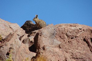
Cerro Colorado (5748 m)Slept very well last night. In the morning it is only -5°, and soon the sun comes. We spend an easy relax and acclimatization day around the campsite, where we meet several vizcachas. In addition we explore a rather strange accumulation of big rocks in the middle of the plain. It must have been a dangerous time here when that had been formed (by a long throw from the distant volcanoes),
Meanwhile Claudia is climbing Cerro Colorado (5748 m). The route from here along the left side of the mountain is rather loose and somewhat delicate in the upper part. After seven hours she is back at the campsite.
 Fumaroles at Volcán Putana |
 Vizcacha |
 |
 Campsite at Cerro Colorado: Outdoor dinner |
Sunday, 14. August
Attempt at Sairecabur (5971 m)After another night at the sulfur mine we drive back towards San Pedro, but we take the western side road to Sairecabur (i.e., not the road to Azufreira Saciel). Of course, there are no signposts, but the map (Openandromaps on the smartphone) is quite good. The road has poor quality, and some snow becomes more and more obstructive. Already at 5130 m we get stuck in the snow, our car has not enough chassis height. A pity, the road would lead up to 5700 meters.
I try the summit from there, following the road. That turns out to be way too far, the road is crossing several flat plains. The last one at 5500 meters takes me 40 minutes without even a meter of height gain. I walk until the observatory which has a lonely position at the edge of the plain. Even if the summit trail would be steeper now, it would take another three hours. Too much for the current lenght of a day, and the walk up to here was quite strenuous, too. 5530 m is my turnaround point.
In the afternoon we return to San Pedro; overnight stay in the hostal. This time there are only four-bed rooms without private bathroom available.
") Cerro Colorado (5748 m) |
 Between Sairecábur and Licancábur a huge crater is located |
 Sairecábur, at the observatory |
Monday, 15. August
Rest day in San PedroTuesday, 16. August
Approach to Acamarachi
Having enjoyed good food in San Pedro for two days, we come to the central part of our "expedition", Volcán Acamarachi (Pili). We also have Cerro Toco on our permit, but we will spare it for later.
The new road to Paso de Jama (CH-27) is paved and in an excellent state. Beyond San Pedro de Atacama it directly leads up the uniform slopes at the right side of Licancabur - 2000 meters of altitude gain at the first 30 kilometers. From the dry desert of the Salar we cross a puna grass vegetation zone in order to end in the cold rock desert of the high puna at almost 5000 meters.
The road is heavily frequented by car transporters, we see several trucks along the road, deposited or abandoned in different states. In most cases apparently the traction engine didn't do the right job.
After the branch-off of the road to Bolivia, the CH-27 winds through vast high plains at an altitude of 4500 to 4800 m, surrounded by many volcano cones. The emptiness of the landscape is somewhat bizarre.
After 80 km we leave the paved road and and follow a GPS track around am Salar de Pujsa to Pili base camp (4575 m). No problem to find the route, there is only one track. The crossing of a frozen river causes a little strain.
At the site, we pitch a tent in which Marion, Henning, and Nina can hold the fort until day after tomorrow. Claudia and I continue 2 1/2 hours by foot to camp 1 which is unfortunately unreachable with our car.
For the big stones in the slope, probably only a real jeep would be sufficient.
Our camp site at 4900 m is soon in the shadow. To reduce our loads we have no stove with us, resulting in only simple food, but that is no problem.
 Road to Paso de Jama |
, 4575 m") Base camp at Acamarachi (Pili), 4575 m |
 The route leads directly towards Acamarachi |
 camp 1, 4870 m |
Wednesday, 17. August
Volcán Acamarachi (Pili), 6046 m
Camp 1 gets sunshine from the sunrise on (7 o'clock), so we can leave alreade at half past seven. After all, we have a lot to do today.
After half an hour the terrain becomes tedious without being steep enough for a good altitude gain: irregular rough and loose rubble. Over and over a cold and annoying northern wind.
Slowly the slope steepens, and after three hours we are at the saddle of the "shoulder" at 5460 m. Here, the actual summit cone is piled up, and it looks not easy.
But we find some traces on the left ridge. Time and again we see something like a small path in a steep walking terrain, soon disappearing again in the rubble.
Sometimes it is useful to use the hands, but it is not real climbing. Further above the slope reclines; here we meet a Chilean descending from the summit on a solo trip, having started at three at night from his car (below our basecamp).
At 2 p.m., after 6 1/2 hours, we reach the summit (6046 m), it is almost calm. The view is phenomenal: For well a hundred kilometers the area is abuzz with other volcano cones.
Not far below the summit, we visit the crater lake which at 5950 m is one of the highest lakes in the world2. Currently it is frozen, and the ice cover is broken.
On the descent, a deviation to the right costs a little time and nerves: The good descent traces were treacherously leading to a vertical cliff. With some effort we find a way back to our trace through delicate and loose terrain.
Back at the tent at 16:30, after dismounting the tent we immediately continue. At half past six we are back with the others in the base camp. There is just enough light to pitch the tent.
 Departing for the only 6000m peak of the region |
 No indication of a reasonable trail |
 Further up, the terrain steepens |
 The summit is in the middle |
 |
 Aguas Calientes and Láscar |
 Láscar is incessantly producing gas clouds |
 Volcán Acamarachi, 6046 m |
 View from west across north to southeast |
 At the shore of the crater lake (5950 m) |
 Deviating from the route leads to awkward, loose terrain |
 Way back to base camp |
Thursday, 18. August
Cerro Negro de Pujsa (5135 m)
The night was cold: The zipper of the inner tent was broken, so we didn't sleep very well, and we have to wait longer here than in camp 1. The sun comes no earlier than half past eight, and before this time no resonably intelligent being would leave the tent.
With Marion and Henning, I go to Cerro Negro de Pujsa which is basically only a short 500 height meter trip. But while at Acamarachi the wind was strong only once in a while, today we have a permanent wind of 50 km/h which makes us feel much colder. On the summit, we find a note of a climb in 2002 in a plastic film bix which unfortunately crumbles to pieces while opening.
The descent in much faster than the ascent. We drive back to a more convenient environment to San Pedro de Atacama.
 on Cerro Negro de Pujsa. In the background Acamarachi") Wood (age unknown) on Cerro Negro de Pujsa. In the background Acamarachi |
 Cerro Negro de Pujsa, 5135 m |
 Instead of a summit book we only find one paper sheet |
 On the way back to San Pedro |
 Guanacos |
Friday, 19. August
Salar de Atacama
Sightseeing program today. We begin with Laguna Cejar, but don't enter - having seen the signs indicating an entrance fee of $15000 per person.
Maybe one can have a bath in there, but for 20 Euros?
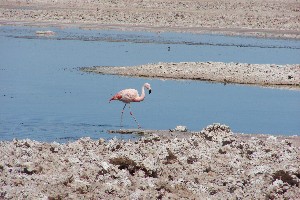
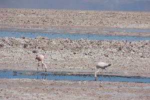
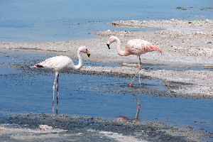
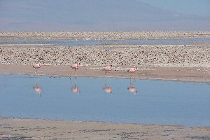
Further in the south, beyond Toconao, things are different: Near Laguna Chaxa ("Salar de Atacama") the fee is only $2500, and we see three different types of flamingos. On the way back we even see a desert fox.
 In the Salar de Atacama |
 Three species of flamingos are living here |
 |
 |
 |
 a small Laguna with Sairecábur, Licancábur, Juriques |
 |
 Desert fox is toddling off, obviously without prey |
 Evening in San Pedro |
Saturday, 20. August
Cerro Toco (5604 m)
Without a stay in the tent, we leave from the hostal to Cerro Toco. Also here a radiotelescope is operating, and the road is in good condition. We can drive up to 5250 m without problems.
For the first time, we are not alone at a mountain: four or five all terrain vehicles are parked along the road, all of them obviously Toco visitors.
At the parking, again we find an inexorable wind. Marion and Henning soon feel too cold, Nina anyway, and the retreat to the car.
Claudia and I reach the summit in two hours. Probably this is the most unextensive 5000m peak at all. We meet several groups of Chileans, escaping from the wind and mostly chilled to the bone. Some of them walk in sneakers.
Only a short rest on the summit, the wind is very annoying and even knocks the camera down when put onto a rock for the self-timer.
It takes only 20 minutes back to the car. Now better equipped with my down jacket, Marion makes a second attempt with Claudia, needing only a little less than an hour for the 350 height meters to the summit.
In San Pedro de Atacama we get back to the carabineros and inform them about our return.
We decide to completely omit our originally scheduled Volcán San Pedro in the north, because a second 6000 m peak with high camp - this time from the shady south side - would be a too big effort. We'd rather undertake some more comfortable things for all the five of us. Twenty years ago we probably would have decided differently, but today as a five person group between 7 and 73 years, there should be interesting and feasible activities for everyone.
 We are not alone at Cerro Toco |
") Cerro Toco (5604 m) |
, Juriques (5704)") Licancábur (5916), Juriques (5704) |
 The radio telescopes are standing in the Chajnantor high plain |
 Cerro Toco: Main summit is in the center below the light reflex |
 Marion joins our second ascent of the day |
Sunday, 21. August
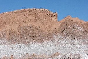
Valle de la LunaThere is no big motivation for archeological education today, so it is (almost) a rest day. In the afternoon we visit the places of Valle de la Luna which we had omitted last time due to lack of time: A long cave3 in the salty rock is interesting especially for Nina. The stone columns Tres Marias are quite far from looking like three Marias. The salt mine at the very end offers interesting insights into the earlier mining activities in the region.
3Important: Take a headlight or lamp with you!  The hike through the cañon is narrow and dark  |
 |
 |
 Salt covering the walls of a small cave |
Monday, 22. August
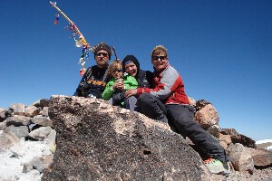
Cerro Toco (5604 m)We start another attempt for Toco, because two days ago Henning and Nina could not go up in the windy weather as they had not enough warm clothes. Today we are equipped better. Big surprise at the parking: It is calm. Further up there is a slight wind, but far from the day before yesterday. We can even go without jacket. In such good conditions, all five of us reach the summit (5604 m). Nina climbs her first 5000 m peak without effort. This is a nice ending for our mountaineering activities here.
 Again on the way to Cerro Toco |
 Nina´s arrival on the summit |
") |
 |
| Cerro Toco (5604 m). The cat was hidden in the summit cairn | |
Tuesday, 23. August
San Pedro - Calama
Back in Calama, we happen to find a good accomodation rather quickly - the "Hostal" sign near the gas station brought us to two tidy and affordable rooms with breakfast and improvisational parking (i0n the courtyard).
The town has not much to offer despite its size (140000 inhabitants). The only bit of green in the center is not usable due to construction work,
the main roads are one big traffic jam because of construction. At least we find a reasonably affordable dinner.
Watching the TV, I notice that the time does not coincide with my watch. It seems to be an hour later. Apparently meanwhile the time zone was changed to summer time.
Good to notice this now - otherwise we would have been an hour too late at the airport.
Wednesday, 24. August
Chiu Chiu / Lasana
In the morning we make an excursion to Chiu Chiu, 30 km north of Calama. The village looks similar to San Pedro de Atacama 20 or 30 years ago: a plaza with a nice, old church, two tiny food stores, a tavern.
The small valley of Rio Loa further above is nicely green, llamas and sheep are grazing in between a large number of old, discarded cars in different states of decomposition.
Pukara de Lasana, the ruins of an old Atacameños settlement of the time 400-1200 AD is also worth a visit.
 Chiu Chiu |
 |
 Pukara de Lasana; in the background, Volcán San Pedro |
Thursday, 25. August
Calama, Chuquicamata
Last night the dogs werde unusually loud. During the day the doze on the sidewalks, at night they defend their districts more or less loudly.
The visit of the copper mine Chuquicamata is an organized half day trip from Calama.
The village Chuquicamata was abandoned in 2007 because of health regulations becoming stricter, the workers were relocated to Calama.
It is interesting to learn about the different procedures of ore dressing (in Spanish and "English"), but it is a bit lengthy.
The gigantic pit which has meanwhile reached a depth of 1000 meters is very impressive. The huge trucks transporting the ore from the bottom of the pit to the exit look like toys from above.
After the dusty Chuqui trip we eventually have a shower, but only in Marion's and Henning's room which is situated above the water tank.
In our room we haven't seen warm water yet.
 Parque El Loa, Calama |
 Size comparison Chuqui truck and normal car |
 Meanwhile the hole is one kilometer deep |
 After an hour the ore arrives at the top |
Friday, 26. August
Flight Calama - SantiagoAt noon we drop the car at the airport, and we have plenty of time until our flight to Santiago is leaving.
In Santiago, we deposit the big bags at the baggage room (which is an expensive business of $25000) and use the Centropuerto bus the the city. Our pre-booked hostel is found soon, it is a rather decent hostal close to the center. After dinner we are soon in bed, tomorrow we have to start early - we have to be at the airport at half past seven.
 Return trip: Andes near Santiago |
Saturday, 27. August / Sunday, 28. August
Flight back Santiago - Buenos Aires - Madrid - MünchenBus ride, fetching the baggage, check-in works perfectly. We get boarding passes only to Buenos Aires and have to look after the Iberia boarding passes there, but the baggage is checked until Munich. Well in time we fly to Buenos Aires where the weather is really ugly: 10°C, rain. We have to wait half an hour in the plane until the door can be opened, apparently it was blocked by freezing. The delay makes us a bit nervous, we only have 1 1/2 hours to the next flight. The way to the gate of the continuation flight is quite long, but we get the boarding passes until Munich and have enough time (but you don't know before if time is short or not). The long flight to Madrid is packed to capacity, and we hardly find any sleep on the central seats. At least one can spend the time watching movies.
The chocolate which was offered at breakfast must have contained considerable traces of peanut which we adults had not tasted: Nina (peanut allergy!) complains about stomach pain and uses all available sickness bags to empty her stomach. Unfortunately the Fenistil drops are in unaccessible the checked baggage. So at Madrid airport we locate a pharmacy which has a comparable allergy medicine. We have to cross the security check several times on the search for the medicine, but in the end everything is good.
On the flight to Munich, Nina's stomach is quiet again; flight and train journey home proceed as scheduled, and we are at home around 5 p.m. Since we had entered the plane in Calama, we have been on the way for 44 hours.
Technical hints about the images
After clicking onto an image, a larger version (height 768 pixels) will be opened in a new tab in the browser.
In this window, a manual or automatic slide show can be started:
- click onto the image -> next image
- click onto right arrow -> next image
- click onto left arrow -> previous image
- click onto clock -> next image, and automatically every 5 seconds the next image will be loadad. This can be interrputed again by one of the above mentioned clicks. The automatic slide show needs JavaScript.
If you don't like the image height 768 (e.g. on notebook or netbook computers): Normally you can change the scaling of the contents using Ctrl-"+" oder Ctrl-"-".
Home |
Back to "Mountains" |
Back to "Expeditions" |
Map sketch |
Height diagramm |
Practical information |
Deutsche Version |
print version (no menus) |
![]() This page is confirmed to comply with the HTML 4.0 standard.
This page is confirmed to comply with the HTML 4.0 standard.
Last updated November 01, 2016 by Hartmut Bielefeldt